The 1930-37 Expeditions of Donald George Mackay
An edited, 10 minute film, The Unexplored Nor’ West by Commander Harry Bennett, Navigator and Surveyor, Mackay Expedition, 1933, may be viewed via this link.
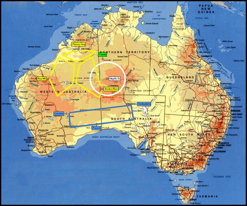
Areas covered by Mackay’s expeditions between 1930 and 1937.
Some background
During 1930-37, Donald George Mackay (1870-1958) led four private aerial survey expeditions to map the largely unknown Australian interior. Until Federation in 1901, the Australian Colonies had gone about their survey and mapping operations individually. This work was generally focussed on ensuring that their land was properly administered. Necessarily, unattractive land of their interior remained mostly unsurveyed and especially unmapped. In the first thirty years following Federation, the new Federal government had to deal with a World War and its aftermath. Thus although there were persistent calls for the Commonwealth to undertake its national survey and mapping obligations there were, it said, higher priories. Mackay decided he would then undertake the mapping task himself.
With a substantial private income, Mackay could be described as an adventurer, having travelled the world, prospected for gold, cycled around Australia, 1900 in a record-breaking time of 240 days after an 11,000 mile (17,703 km), investigated the headwaters of the Purari River in Papua, sailed a yacht in the South Pacific and visited New Zealand and the Dutch East Indies.
For the first expedition in 1930, a base camp was established near llbpilla Soak about 350 km north-west of Alice Springs. From there the work extended radially out to a distance of about 250km. This expedition found a very large, dry lake astride the Western Australia /Northern Territory border. This lake is now known as Lake Mackay.
A second expedition took place in 1933 and operated from Docker River in the Northern Territory and Roy Hill and Fitzroy Crossing in Western Australia. The three base sites formed a triangle with sides about 1000 km in length (the range of Mackay’s aircraft). From these bases, large areas of the Great Sandy and Gibson Deserts were surveyed.
Mackay’s 1935 expedition surveyed a strip of country about 1400 km long and about 500 km wide, immediately to the north of the transcontinental railway. It used bases at Cook, Forrest, Laverton, Oodnadatta and Rawlinna.
The fourth and final expedition in 1937 was based at Tanami (about 470 km due west of Tennant Creek) and Roy Hill again. The 1937 expedition filled in some gaps from previous flights.
Although the final maps could only be regarded as reconnaissance nonetheless they portrayed significant topographic features.
Sources
Carment, David (1986), Mackay, Donald George (1870-1958), Australian Dictionary of Biography, National Centre of Biography, Australian National University, accessed at : https://adb.anu.edu.au/biography/mackay-donald-george-7377
Wise, Paul Joseph (2011), Australia’s First 1: 250 000 Scale, Uniform Topographic Map Coverage : The R502 Story, Presented paper 100 Years of National Topographic Mapping Conference, Canberra, 2011.